Sri Lanka's Topographic Diversity in a Small Area
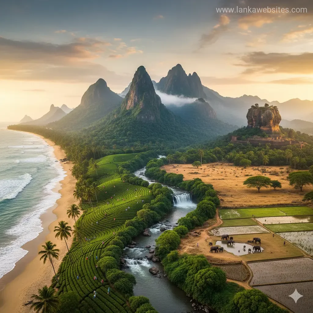
Despite being one of South Asia's smallest island nations, Sri Lanka packs an extraordinary range of landscapes into just 65,610 square kilometres. From pristine coastal beaches to misty mountain peak
The Lankawebsites editorial team curates, fact-checks, and updates guides on personal finance, property, health, immigration, legal, business, and lifestyle topics relevant to Lankawebsites readers. Articles are produced with AI assistance and reviewed by the editorial team before publication.
Despite being one of South Asia's smallest island nations, Sri Lanka packs an extraordinary range of landscapes into just 65,610 square kilometres. From pristine coastal beaches to misty mountain peaks, lush tropical forests to arid plains, our island's topographic diversity is genuinely remarkable. What makes this even more impressive is how these distinct regions exist within such close proximity—you can travel from a sandy beach to a mountain peak reaching over 2,500 metres in just a few hours. Understanding this geographical variety isn't just fascinating; it's essential for anyone planning to explore our country, invest in land, or simply appreciate what makes Sri Lanka so geographically unique.
Three Distinct Topographic Zones
Sri Lanka's landscape naturally divides into three main zones based on elevation, each with its own character and significance. These zones have shaped everything from our climate patterns to our settlement patterns and economic activities.
The Central Highlands: Our Mountain Heart
The south-central region contains our most dramatic terrain—a mountainous plateau that rises dramatically from the surrounding plains. The highest point is Pidurutalagala at 2,524 metres (8,281 feet), which dominates the landscape and influences weather patterns across the entire island. This highland plateau runs roughly north to south for approximately 65 kilometres and features several other significant peaks.
Adam's Peak, standing at 2,243 metres, is perhaps our most famous mountain and holds deep spiritual significance for Buddhists, Hindus, Muslims, and Christians alike. Namunukula reaches 2,036 metres, whilst the Knuckles Massif—a World Heritage Conservation Area—features steep escarpments and deep gorges with peaks exceeding 1,800 metres.
The Central Highlands aren't just mountains; they're a complex system of ridges, peaks, plateaus, and basins. To the west lies the Hatton Plateau, whilst the Uva Basin to the east features rolling hills interspersed with deep valleys and gorges. This rugged terrain has historically influenced settlement patterns, with communities developing in accessible valleys and plateaus rather than on the steepest slopes.
The Plains: Our Largest Region
Covering most of our island, the plains represent the most accessible and economically significant zone. About 80 percent of Sri Lanka is flat or gently rolling terrain, with elevations between 30 and 200 metres above sea level. This vast area surrounds the Central Highlands on all sides, creating a natural transition zone between mountains and coast.
The plains aren't uniform—they vary considerably by region. In the southwest, ridges and valleys gradually rise toward the Central Highlands, creating what geographers call a "dissected appearance." Extensive erosion over millennia has worn down these ridges and deposited rich soil downstream, making this area particularly fertile for agriculture.
The southeastern plains display a different character entirely. Here, red lateritic soil covers relatively level ground studded with bare monolithic hills that rise abruptly from the landscape. The transition from plain to mountains here is dramatic—the highlands seem to rise like a wall rather than gradually ascending.
In the east and north, the plains are flatter still, dissected by long, narrow ridges of granite running from the Central Highlands. This region experiences different rainfall patterns and has historically been less densely populated than the southwestern plains.
The Coastal Belt: Our Gateway to the Ocean
Encircling the entire island is our coastal belt—a scenic zone that rises from sea level to approximately 30 metres elevation. This region features the stunning beaches, lagoons, and mangrove swamps that define Sri Lanka for many visitors and residents alike.
The coastal landscape varies considerably around the island. Much of our coastline features beautiful sandy beaches and lagoons lined with mangroves. However, in certain areas—particularly the northeast and southwest—rocky cliffs and bays formed by crystalline rock stratification create dramatic seascapes. Our total coastline stretches for 1,340 kilometres, providing diverse marine and coastal ecosystems.
Geological Foundations: Ancient Rock Formations
Understanding Sri Lanka's topography requires knowing what lies beneath. More than 90 percent of our island's surface rests on Precambrian strata, some dating back 2 billion years. This ancient geological foundation explains much about our current landscape.
The Central Highlands consist primarily of granulite facies rocks—gneisses, sillimanite-graphite gneisses, quartzite, marbles, and charnokites—which are metamorphic rocks created when ancient sediments were transformed under intense heat and pressure during mountain-building processes. In the eastern and southeastern lowlands, you'll find amphibolites gneisses, granites, and granitic gneisses instead.
According to plate tectonics theory, these rocks—along with similar formations across south India—were once part of a single southern landmass called Gondwanaland. When this supercontinent broke apart millions of years ago, it set the stage for the formation of our current island landscape. The northwest coast remains connected to the deep Cauvery River Basin of southeast India, which has been collecting sediments from both regions since Gondwanaland's breakup.
How Topography Shapes Our Climate and Biodiversity
Our topographic diversity directly influences rainfall distribution and climate patterns. The Central Highlands act as a barrier to moisture-laden winds, creating dramatically different climates on the windward and leeward sides. The southwestern plains and western slopes receive significantly more precipitation than the northern and eastern regions, resulting in lush tropical rainforests in some areas and arid zones in others.
This climatic variation supports extraordinary biodiversity. The Knuckles Massif, for example, is home to mammals including wild boar, spotted deer, giant squirrels, barking deer, purple-faced leaf monkeys, mongooses, and porcupines. Dense tropical vegetation in wetter regions includes giant tree ferns, towering palms, and valuable tropical hardwoods such as ebony and satinwood.
Rivers and Water Systems
Our topography has shaped an intricate network of water systems. 103 rivers flow from the Central Highlands in a radial pattern toward the sea, with 16 principal rivers longer than 100 kilometres. Twelve of these major rivers carry approximately 75 percent of the mean river discharge across the entire island.
Most of these rivers are relatively short because of our island's small size, but they play crucial roles in agriculture, hydroelectric power generation, and water supply. The radial flow pattern—with rivers flowing outward from the highlands like spokes from a wheel—is a direct consequence of our topographic structure.
Practical Implications for Sri Lanka Residents
Transportation and Accessibility
Our topographic diversity significantly affects travel times and transportation infrastructure. Journey times between regions can vary dramatically depending on terrain. Roads through mountainous areas require more careful engineering and maintenance, whilst plains-based routes are generally more straightforward to develop and maintain.
Agriculture and Land Use
Different topographic zones support different agricultural activities. The fertile southwestern plains are ideal for paddy cultivation and vegetable farming, whilst the Central Highlands' cooler temperatures and higher rainfall support tea cultivation, which remains economically vital for many communities. Understanding local topography helps determine which crops can be successfully grown in your area.
Development and Settlement
Topography influences where communities develop and how they expand. Steep slopes require specialised building techniques and higher construction costs. Flood risk varies considerably by elevation and proximity to river systems. If you're considering property investment or relocation, understanding local topography is essential.
Frequently Asked Questions
What's the highest mountain in Sri Lanka?
Pidurutalagala is our highest peak at 2,524 metres (8,281 feet) above sea level. Adam's Peak, at 2,243 metres, is more famous due to its religious significance and popularity with pilgrims and hikers.
How much of Sri Lanka is mountainous?
Approximately 20 percent of Sri Lanka is mountainous or significantly elevated. The remaining 80 percent consists of plains and coastal regions. This makes our island predominantly low-lying, with mountains concentrated in the south-central region.
Why does Sri Lanka have such diverse climates in such a small area?
Our topographic diversity is the primary reason. The Central Highlands block moisture-laden winds, creating wet zones on windward slopes and dry zones on leeward slopes. Additionally, temperature decreases with elevation, so higher mountain regions are significantly cooler than lowland areas.
Which areas are most prone to flooding?
Low-lying plains areas, particularly near river systems, are most flood-prone. The southwestern plains, which receive the highest rainfall, experience more frequent flooding than drier regions. Understanding local topography and proximity to rivers helps assess flood risk for any location.
Can I see the mountains from the coast?
From many coastal locations, particularly in the southwestern region, you can see the Central Highlands in the distance on clear days. However, the distance and atmospheric conditions mean that the highest peaks aren't always visible from sea level.
How old is Sri Lanka's landscape?
The geological foundation is extraordinarily ancient—over 90 percent of our island rests on Precambrian rocks dating back up to 2 billion years. However, the current topographic features have been shaped by erosion, faulting, and weathering over millions of years.
Exploring Our Topographic Diversity
What makes Sri Lanka truly special is how you can experience such dramatic topographic contrasts within a single day's journey. You might start your morning swimming in the Indian Ocean, travel through fertile agricultural plains, ascend into misty mountain forests, and return to the coast before sunset. Few places on Earth offer such concentrated geographical diversity.
Whether you're planning to explore our landscapes, invest in property, develop agricultural projects, or simply understand our country better, recognising the three main topographic zones—the Central Highlands, the plains, and the coastal belt—provides a framework for understanding everything from our climate and biodiversity to our infrastructure and economic opportunities.
Take time to explore different regions and observe how topography shapes the landscape, the people, and the possibilities in each area. Our small island's remarkable geographical variety is one of our greatest assets.
Related Articles

Ella Gap: Scenic Mountain Pass in Central Highlands
Introduction to Ella Gap The Ella Gap is a breathtaking mountain pass located in the Central Highlands of Sri Lanka, but don't worry, we're not talking abo

Sri Lanka's Continental Shelf and Marine Territory
Introduction to Sri Lanka's Continental Shelf and Marine Territory As a New Zealander, you might be familiar with the concept of a continental shelf, but h

The North Central Province: Ancient Reservoir Systems
Introduction to the North Central Province The North Central Province, located in the heart of Sri Lanka, is a region steeped in history and natural beauty

Minneriya-Giritale-Kaudulla Complex Geography
Introduction to Minneriya-Giritale-Kaudulla Complex Geography The Minneriya-Giritale-Kaudulla Complex, located in the North Central Province of Sri Lanka,