Coastal Belt Features and Lagoons of Sri Lanka
Sri Lanka's coastal belt is one of the island's most defining geographical features, stretching over 1,340 kilometres and encompassing a rich tapestry of lagoons, wetlands, and marine ecosystems[4]. F
The Lankawebsites editorial team curates, fact-checks, and updates guides on personal finance, property, health, immigration, legal, business, and lifestyle topics relevant to Lankawebsites readers. Articles are produced with AI assistance and reviewed by the editorial team before publication.
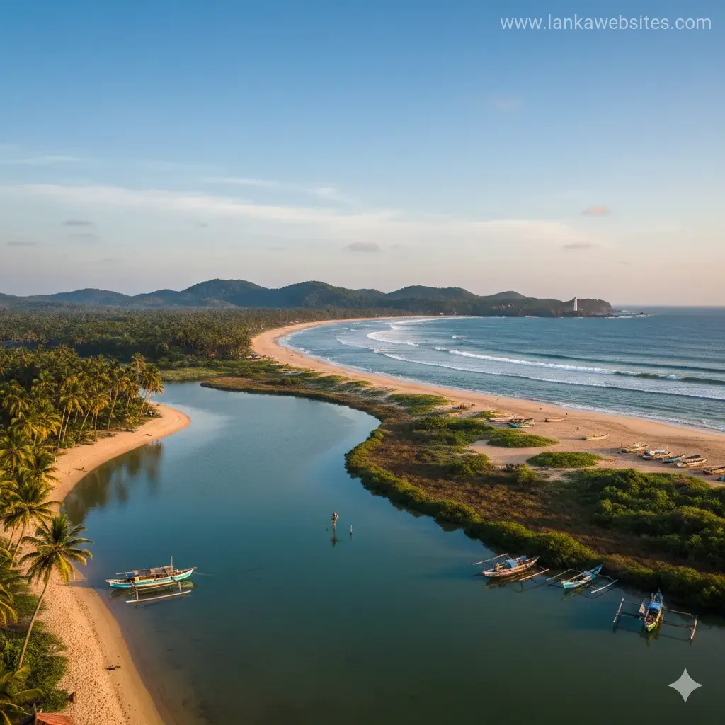
Sri Lanka's coastal belt is one of the island's most defining geographical features, stretching over 1,340 kilometres and encompassing a rich tapestry of lagoons, wetlands, and marine ecosystems. From the palm-fringed beaches of the southwest to the ecologically sensitive mangrove systems of the north, our coastal regions represent both natural beauty and economic opportunity. Understanding these coastal features isn't just about geography—it's about recognising the ecosystems that sustain our fishing communities, support tourism, and protect us from coastal hazards.
Understanding Sri Lanka's Coastal Geography
Sri Lanka is a pear-shaped island positioned in the Indian Ocean, lying just 18 miles from India at its closest point. What makes our coastline particularly distinctive is its remarkable diversity. Rather than a uniform shoreline, we have a varied topography that includes sandy beaches, rocky promontories, deep-water bays, offshore islets, spits, and lagoons.
The island's total coastline measures 833 miles (1,340 kilometres), and this extensive maritime boundary profoundly influences our climate, culture, and economy. Our territorial sea extends 12 nautical miles from the coastline, establishing our maritime jurisdiction and resource boundaries.
The Coastal Plain Structure
The coastal plains surrounding Sri Lanka's Central Highlands vary significantly in width and character depending on their location. The western and southwestern parts of the plain feature alternating ridges and valleys running parallel to the coast, with elevations increasing toward the interior. These broader plains have historically supported dense population centres and extensive agricultural activities.
To the north and northeast of the highlands, the plain is traversed by low ridges that gradually decrease in altitude as they approach the coast. This gradual transition creates a gentler landscape compared to the more dramatic southwestern terrain. Elsewhere around the island, the flatness of the plain is interrupted by rocky buttes and mounds, some reaching elevations of more than 1,000 feet, adding further diversity to our coastal geography.
Lagoons: Sri Lanka's Ecological Treasures
Our lagoons represent some of the most biologically productive and ecologically important features of the Sri Lankan coastline. These shallow water bodies, separated from the ocean by sandbars or coral formations, create unique ecosystems that support diverse wildlife and human livelihoods.
The Jaffna Lagoon System
One of our most significant lagoon systems is the Jaffna lagoon, particularly notable for its ecological richness and vulnerability. The Jaffna Peninsula lies entirely within 10 kilometres of the coast and has an almost flat topography, with approximately 50% of the land area less than 2 metres above sea level. This low elevation makes the region highly vulnerable to sea-level rise and coastal hazards, a concern that's increasingly important as we consider future development.
The Jaffna lagoon system forms an ecologically rich mosaic of mangroves, seagrass beds, mudflats, salt marshes, and coastal wetlands. These interconnected ecosystems create a complex web of life that sustains multiple industries and species.
Biodiversity and Livelihood Support
Our lagoons aren't simply scenic features—they're economic lifelines for many communities. The Jaffna lagoon system sustains artisanal fisheries and provides nursery grounds for marine species, whilst also attracting migratory birds. The region is particularly known for prawn and crab fisheries, which depend directly on the health of mangrove ecosystems.
Mangroves, which fringe many of our lagoons, are highly sensitive to changes in salinity and hydrology. Even seemingly minor infrastructure modifications, such as roads, can fragment habitats and disrupt the tidal exchange that these ecosystems depend upon. This sensitivity underscores why careful planning around lagoon areas is essential.
Coastal Features: From Southwest to North
The Southwestern Coastline
The southwestern coast represents one of Sri Lanka's most recognisable and developed coastal regions. It's particularly renowned for its palm-fringed beaches, coral reefs, and lagoons that create ideal conditions for both tourism and fishing. The broader coastal plains in this region have supported extensive population centres and agricultural development over centuries.
This region's combination of natural beauty and accessibility has made it a hub for the tourism industry, generating significant economic benefits for local communities. The sandy beaches and shallow waters make it particularly suitable for water-based activities and resort development.
Northern Coastal Areas and Islands
The northern islands present a contrasting coastal environment. Mandaitivu, a low-lying island within the Jaffna lagoon system, rises only about 5 metres above sea level and covers 7.6 square kilometres. Islands like this are particularly vulnerable to environmental changes and require thoughtful development planning.
According to the Greater Jaffna Development Plan (2024-2034), areas like Mandaitivu are designated as "high sensitivity" zones where development should be minimised, with proposals for mangrove forest reserves. National and provincial environmental assessments recommend nature-based tourism rather than large-scale infrastructure for the northern islands.
Rocky Promontories and Deep-Water Bays
Over several stretches of our coastline, the sandy beaches give way to rocky promontories and cliffs, with deep-water bays and offshore islets adding further geographical diversity. These rocky coastal features create distinctive landscapes and support different ecosystems compared to our sandy beach areas.
Marine Ecosystems and Water Resources
The Gulf of Mannar
To the northwest lies the Gulf of Mannar, a shallow bay that serves as a biological treasure trove with its coral reefs and marine ecosystems. This region represents one of our most important marine resource areas, supporting both fishing communities and marine biodiversity.
The Bay of Bengal
The Bay of Bengal stretches to the northeast, whilst the vast expanse of the Indian Ocean surrounds our southern and western coasts. These different water bodies create distinct maritime zones with varying characteristics and resource potential.
Coastal Soils and Agricultural Significance
The soils within our coastal zones reflect the effects of climate, lithology, and terrain on soil-forming processes. In the Wet Zone coastal areas, red-yellow podzolic soils (leached lateritic soils) dominate, whilst in the Dry Zone coastal regions, reddish brown earths (nonlateritic loamy soils) are more prevalent.
These soil variations influence what can be cultivated in different coastal regions and how land responds to development and environmental changes. Understanding these soil characteristics is important for anyone involved in coastal agriculture or development planning.
Natural Hazards and Coastal Protection
Our coastal ecosystems, particularly mangroves and wetlands, provide natural protection against storms and coastal erosion. The mangrove systems act as natural buffers that reduce the impact of monsoons and coastal storms on inland areas.
Large-scale development in sensitive coastal areas can destroy this natural water storage capacity and disrupt tidal flows, significantly increasing flood risks during monsoons and coastal storms. This is why environmental assessments and thoughtful planning are crucial before undertaking major coastal development projects.
Frequently Asked Questions
What makes Sri Lanka's coastline unique?
Sri Lanka's coastline is distinctive because of its remarkable diversity rather than uniformity. We have sandy beaches, rocky promontories, deep-water bays, offshore islets, spits, and lagoons all within our 1,340-kilometre coastline. This variety creates different ecosystems and supports different economic activities in different regions.
How long is Sri Lanka's coastline?
Sri Lanka's coastline stretches over 1,340 kilometres (833 miles). Our territorial sea extends 12 nautical miles from the coastline.
What are the main lagoon systems in Sri Lanka?
Whilst the search results specifically detail the Jaffna lagoon system, Sri Lanka has multiple lagoon systems along its coast. The Jaffna lagoon is particularly notable as an ecologically rich mosaic of mangroves, seagrass beds, mudflats, salt marshes, and coastal wetlands.
Why are mangroves important to Sri Lanka's coastal regions?
Mangroves sustain artisanal fisheries, provide nursery grounds for marine species, attract migratory birds, and act as natural buffers against storms and coastal erosion. They're particularly important for prawn and crab fisheries and provide livelihoods for many coastal communities.
How vulnerable are Sri Lanka's northern coastal areas?
The Jaffna Peninsula is particularly vulnerable, with approximately 50% of the land area less than 2 metres above sea level. This makes the region highly susceptible to sea-level rise and coastal hazards, requiring careful environmental management and development planning.
What environmental protections exist for sensitive coastal areas?
The Greater Jaffna Development Plan (2024-2034) designates high-sensitivity zones where development should be minimised, with proposals for mangrove forest reserves. National and provincial environmental assessments recommend nature-based tourism rather than large-scale infrastructure for sensitive northern islands.
Conclusion: Protecting Our Coastal Heritage
Sri Lanka's coastal belt represents far more than just a geographical boundary—it's an intricate system of ecosystems, economic opportunities, and natural hazards all interconnected within our 1,340-kilometre shoreline. From the palm-fringed beaches of the southwest to the ecologically sensitive mangrove systems of the north, these coastal features define much of what makes our island unique.
Whether you're involved in tourism, fishing, agriculture, or development planning, understanding our coastal geography and the delicate balance of these ecosystems is essential. The lagoons that fringe our coastline, the mangroves that protect our communities, and the diverse soils that support our agriculture all depend on thoughtful stewardship and informed decision-making.
As we continue to develop and grow as a nation, we must remember that our coastal resources are finite and interconnected. The environmental assessments, development plans, and conservation efforts currently in place reflect a growing recognition that protecting our coastal heritage isn't just environmentally responsible—it's economically essential for our fishing communities, tourism industry, and future generations.
Related Articles

Ella Gap: Scenic Mountain Pass in Central Highlands
Introduction to Ella Gap The Ella Gap is a breathtaking mountain pass located in the Central Highlands of Sri Lanka, but don't worry, we're not talking abo

Sri Lanka's Continental Shelf and Marine Territory
Introduction to Sri Lanka's Continental Shelf and Marine Territory As a New Zealander, you might be familiar with the concept of a continental shelf, but h

The North Central Province: Ancient Reservoir Systems
Introduction to the North Central Province The North Central Province, located in the heart of Sri Lanka, is a region steeped in history and natural beauty

Minneriya-Giritale-Kaudulla Complex Geography
Introduction to Minneriya-Giritale-Kaudulla Complex Geography The Minneriya-Giritale-Kaudulla Complex, located in the North Central Province of Sri Lanka,